MDPI News | 期刊Drones 被Scopus数据库收录
发表时间:2020-05-27 阅读量:12433

Drones期刊衷心感谢期刊主编、编委的努力,
以及作者、审稿人、读者的大力支持与贡献!
Drones (ISSN 2504-446X) 于2017年创刊,是MDPI出版的开放获取期刊,由西班牙萨拉曼卡大学的Diego Gonzalez-Aguilera教授担任主编至今。2019年,Drones平均一审周期约为17.9天,文章从接收到发表仅需3.5天。目前,Drones的编委会由14个国家或地区的36名知名学者组成。Drones主要刊载无人机、遥控飞机系统、水下无人机和无人系统等相关的最新科学技术及应用。
主编介绍

Prof. Diego Gonzalez-Aguilera
西班牙萨拉曼卡大学全职教授,地图学和土地工程部主任,TIDOP研究小组的负责人。
研究领域:摄影测量、激光扫描、三维建模、地形、制图学。
他在国际期刊和会议论文集上发表了150多篇研究论文。2015年,他的作品对知识进步的贡献得到了皇家工程学院的认可,获得了皇家工程学院颁发的“Juan Lopez de Penalver”奖。
Drones研究领域及代表性文章
1. 无人机相关的设计:包含板载传感器设计、机身及结构设计、电源、几何和辐射传感器、传感器融合、影像的校正、控制系统、信号/图像处理、纳米无人机或纳米技术。
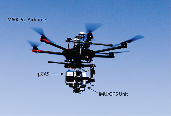
Implementation of a UAV–Hyperspectral Pushbroom Imager for Ecological Monitoring
用于生态监测的无人机高光谱推扫式成像仪的实施
点击后方链接,阅读英文原文:https://www.mdpi.com/2504-446X/3/1/12
J. Pablo Arroyo-Mora, Margaret Kalacska, Deep Inamdar, Raymond Soffer, Oliver Lucanus, Janine Gorman, Tomas Naprstek, Erica Skye Schaaf, Gabriela Ifimov, Kathryn Elmer and George Leblanc
在本文中,加拿大的学者们展示了一种用于生态研究的高光谱传感器—UAV-μCASI。作者通过其设计的UAV-μCASI系统,在The Mer Bleue peatland进行实施和测试,以得到早期的影像结果。通过分析该系统辐射度和几何数据质量,确认了展示收集和严格处理补充的现场数据对于生成和评估图像质量的重要性。文中总结并阐述了该系统要全面运行的基本要求和技术挑战,旨在为生物多样性评估和生态监测的综合方法做出贡献。
2. 无人机相关的发展:包含性能、控制系统、任务规划、安全系统、自治、导航和位置/方向、自主起飞和降落、人工智能、机器学习、同步定位和映射、管制和非管制空域、气象学、GNSS中断、规章制度和经济影响。
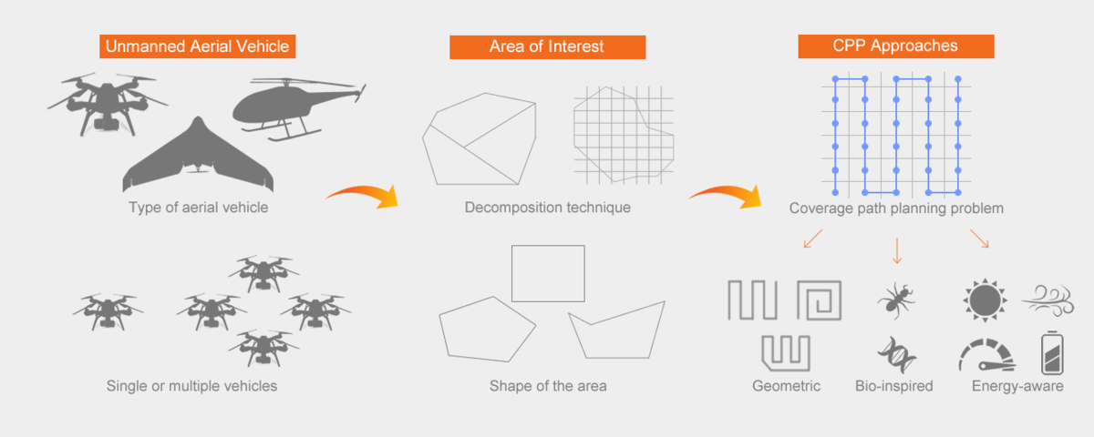
Survey on Coverage Path Planning with Unmanned Aerial Vehicles
无人机覆盖路径规划研究
点击后方链接,阅读英文原文:https://www.mdpi.com/2504-446X/3/1/4
Tauã M. Cabreira, Lisane B. Brisolara and Paulo R. Ferreira Jr.
这篇文章结合有关领域的全部和部分信息,提出了简单的几何飞行模式和更复杂的基于网格的解决方案。在研究中作者使用了经典分类,并考虑了感兴趣区域的不同形状,最后还介绍并验证了通常用于评估覆盖任务成功与否的性能指标。作者旨在探索和分析文献中关于不同方法在覆盖路径规划问题中应用的研究,特别是使用无人机的研究。
2. 无人机相关的应用:包含环境、农业、林业、地球科学、城市、物流、灾难援助、保安及监察、体系结构、监控、变更检测、健康、海洋科学、教育。
Identification of Citrus Trees from Unmanned Aerial Vehicle Imagery Using Convolutional Neural Networks
利用卷积神经网络识别无人机图像中的柑橘树
点击后方链接,阅读英文原文:https://www.mdpi.com/2504-446X/2/4/39
Ovidiu Csillik, John Cherbini, Robert Johnson, Andy Lyons and Maggi Kelly
本文使用一个简单的卷积神经网络(CNN)算法从无人机图像中检测柑橘和其他农作物树,然后使用一个简单的线性迭代聚类(SLIC)算法派生的超像素进行分类细化。该工作流在相对复杂的农业环境(多目标、多尺寸树和年龄等)中表现良好,实现了较高的准确度。
但是监测每棵树的生长、果实产量和病虫害的发生仍然是一项高度研究和业务优先事项,使用自动化方法而不是人工方法对每棵树进行圈定将有助于今后长期的作物管理。据我们所知,这是CNN第一次被用于无人机多光谱图像聚焦柑橘树。我们需要更多这样的个案来开发标准的自动化工作流,以帮助农业管理人员更好地将大量高分辨率无人机图像集成到农业管理操作中。

文章推荐
1. Collaboration of Drone and Internet of Public Safety Things in Smart Cities: An Overview of QoS and Network Performance Optimization
Saeed H. Alsamhi., Ou Ma, M. Samar Ansari and Sachin Kumar Gupta
https://www.mdpi.com/2504-446X/3/1/13
2. Assessment of Chimpanzee Nest Detectability in Drone-Acquired Images
Noémie Bonnin, Alexander C. Van Andel, Jeffrey T. Kerby, Alex K. Piel, Lilian Pintea and Serge A. Wich
https://www.mdpi.com/2504-446X/2/2/17
3. Drones for Conservation in Protected Areas: Present and Future
Jesús Jiménez López. and Margarita Mulero-Pázmány
https://www.mdpi.com/2504-446X/3/1/10
4. Thermal Imaging of Beach-Nesting Bird Habitat with Unmanned Aerial Vehicles: Considerations for Reducing Disturbance and Enhanced Image Accuracy
Kerry L. Mapes, Narcisa G. Pricope, J. Britton Baxley, Lauren E. Schaale and Raymond M. Danner
https://www.mdpi.com/2504-446X/4/2/12
5. Drone-Based High-Resolution Tracking of Aquatic Vertebrates
Vincent Raoult, Louise Tosetto and Jane E. Williamson
https://www.mdpi.com/2504-446X/2/4/37
6. Reef Rover: A Low-Cost Small Autonomous Unmanned Surface Vehicle (USV) for Mapping and Monitoring Coral Reefs
George T. Raber and Steven R. Schill
https://www.mdpi.com/2504-446X/3/2/38
7. UAVs in Support of Algal Bloom Research: A Review of Current Applications and Future Opportunities
Chippie Kislik, Iryna Dronova and Maggi Kelly
https://www.mdpi.com/2504-446X/2/4/35
8. Estimating Mangrove Forest Volume Using Terrestrial Laser Scanning and UAV-Derived Structure-from-Motion
Angus D. Warfield and Javier X. Leon
https://www.mdpi.com/2504-446X/3/2/32
9. A Review on the Use of Unmanned Aerial Vehicles and Imaging Sensors for Monitoring and Assessing Plant Stresses
Jayme Garcia Arnal Barbedo
https://www.mdpi.com/2504-446X/3/2/40
10. Assessing the Accuracy of Digital Surface Models Derived from Optical Imagery Acquired with Unmanned Aerial Systems
Salvatore Manfreda, Petr Dvorak, Jana Mullerova, Sorin Herban, Pietro Vuono, José Juan Arranz Justel and Matthew Perks
https://www.mdpi.com/2504-446X/3/1/15
11. Coastal Mapping Using DJI Phantom 4 RTK in Post-Processing Kinematic Mode
Yuri Taddia, Francesco Stecchi and Alberto Pellegrinelli
https://www.mdpi.com/2504-446X/4/2/9
12. Multirotor Drone Aerodynamic Interaction Investigation
Dhwanil Shukla and Narayanan Komerath
https://www.mdpi.com/2504-446X/2/4/43
13. An Annular Wing VTOL UAV: Flight Dynamics and Control
Rajan Gill and Raffaello D'Andrea
https://www.mdpi.com/2504-446X/4/2/14
版权声明:
*本文内容由MDPI中国办公室编辑负责翻译,一切内容请以英文原版为准。如需转载,请邮件联系:
mdpicnmarketing@mdpi.com
*文中部分图片来源于网络